Sandy beach hydrodynamics and morphodynamics, Truc-Vert 2008 field experiment


| ECORS Truc-Vert 2008
Sandy beach hydrodynamics and morphodynamics, Truc-Vert 2008 field experiment |
|

|

|

|

|
Exploring
beach morphodynamic and hydrodynamic processes has been a challenging task for
many decades. Key in improving our understanding of physical processes has been
the many field experiments conducted by researchers all around the world. Field
observations are a continuous and endless source to identify new processes,
generate and test novel hypotheses, and ultimately improve prediction skills of
nearshore evolution. Moreover, they provide the only possibility for studying
hydrodynamical and sediment transport processes under natural conditions.
Collecting field data remains a key objective in coastal research for many
other reasons: it allows model calibration and validation, and
it drives, informs and complements controlled laboratory experiments. Thanks
to field experiments, much progress has been made this last decade, in understanding
fluid and sediment processes in nearshore hydrodynamics. Barred beaches have
received great attention in the coastal morphodynamic literature by means of
short-duration (< weeks) field experiments (among many others, Thornton et
al., 1996; Gallagher et al., 1998; Ruessink et al., 1998; Ruessink et al.,
2001; MacMahan et al., 2005; Aagaard et al., 2005; Masselink et al., 2008,
Bruneau et al., 2009), long-term (> years) observations (among others Ruessink and Kroon, 1994, Plant et al., 2001; Van
Enckevort and Ruessink, 2003a, 2003b, Ranasinghe et al., 2004, Turner et al., 2007; Quartel et al., 2007, Senechal
et al., 2009), numerical modelling approaches (among others Reniers et al.,
2004; Garnier et al., 2006, Hsu et al., 2006; Dronen and Deigaard, 2007; Smit
et al., 2008) and physical modelling approaches (e.g. Grasso et al., 2009;
Castelle et al., 2009). Many studies have shown that nearshore wave
transformation, circulation and bathymetric changes involve coupled processes
at many spatial and temporal scales (among others Symonds and Ranansinghe,
2000; Plant et al., 2001; Feddersen et al., 2003; Coco and Murray, 2007;
Ruessink et al., 2007; Thornton et al., 2007; Pape and Ruessink, 2008) thus
implying the need to improve knowledge at the full spectrum of temporal and spatial
scales to achieve a comprehensive view of the natural system.
Despite
efforts and progresses, there is still a lack in understanding of nearshore morphodynamics
in presence of a single storm and post-storm event over complex 3D morphologies
but also more generally in presence of a rapid succession of storm/post-storm
conditions. Most of the previous field experiments including the ones that
involved the collection of comprehensive (covering several temporal and spatial
scales) data set have been conducted in presence of low to high energetic waves
(offshore Hmo > 5 m). Detailed observations
spanning the full range of space and time-scales in presence of extreme
energetic waves, meso- to macro-tidal ranges and 3D morphologies has always
been an unsolved and overwhelming challenge for the nearshore community. The Truc
Vert’08 field experiment was designed to fill gaps in previous field
experiments by providing new observations that incorporate extreme storm waves
(Hmo up to 8m), macro-tidal conditions and complex three-dimensional
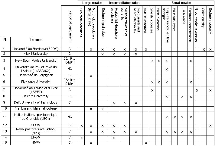
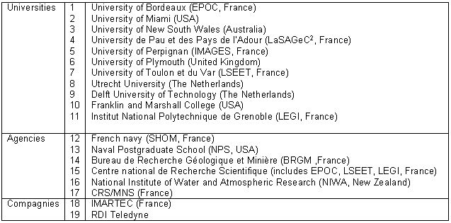
morphology. Considerable interest was expressed for ECORS- Truc Vert’08. Table
1 lists the 19 organizations that participated, involving more than 120
scientists, engineers, technicians, militaries and students. Table 2 lists the main topics of interest at
the different temporal and spatial scales and the organizations working on them
during the field experiment.
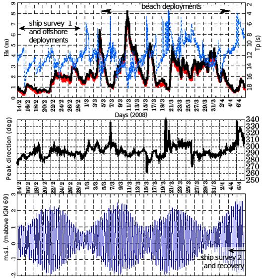
Hydrodynamic
conditions during the field experiment: (upper panel) significant wave height
measured by the waver rider buoys: 20 m water depth (red line) and 50 m water
depth (black line), peak period (blue line). (middle panel) peak direction, 280
is the normal incidence for
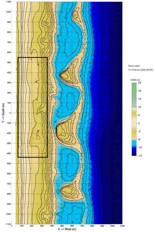
Bathymetric
survey of the area, the black box represents the sensor deployment zone
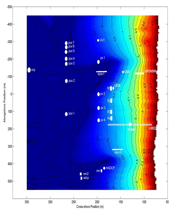
Focus
on the intertidal area, bathymetry isolines
ECORS Truc Vert’08 Topics